St. Lawrence (river) - geography.IINTRODUCTIONSt. Lawrence River, QuébecQuébec, a name
Publié le 18/05/2020

Extrait du document
«
St.
Lawrence (river) - geography.
IINTRODUCTION
St.
Lawrence River, QuébecQuébec, a name derived from an Algonquian term meaning “place where the river narrows,” is a Canadian city that lies on thejuncture of the St.
Lawrence and St.
Charles rivers.
Here, the French-style hotel Château Frontenac sits beside the St.
Lawrence Riverin the Old Québec district.Porterfield-Chickering/Photo Researchers, Inc.
- geography.
St.
Lawrence (river) (French Saint-Laurent ), river in eastern North America.
The chief outlet of the Great Lakes, the St.
Lawrence flows northeast from Lake Ontario to the Gulf of St.
Lawrence on the North Atlantic Ocean, a distance of 1,300 km (800 mi).
As part of the St.
Lawrence Seaway, a system of canals, locks, and dredged channelsbuilt to allow the passage of oceangoing vessels, the St.
Lawrence River serves as a major water route to the interior of the United States and Canada, linking the GreatLakes with the Atlantic Ocean.
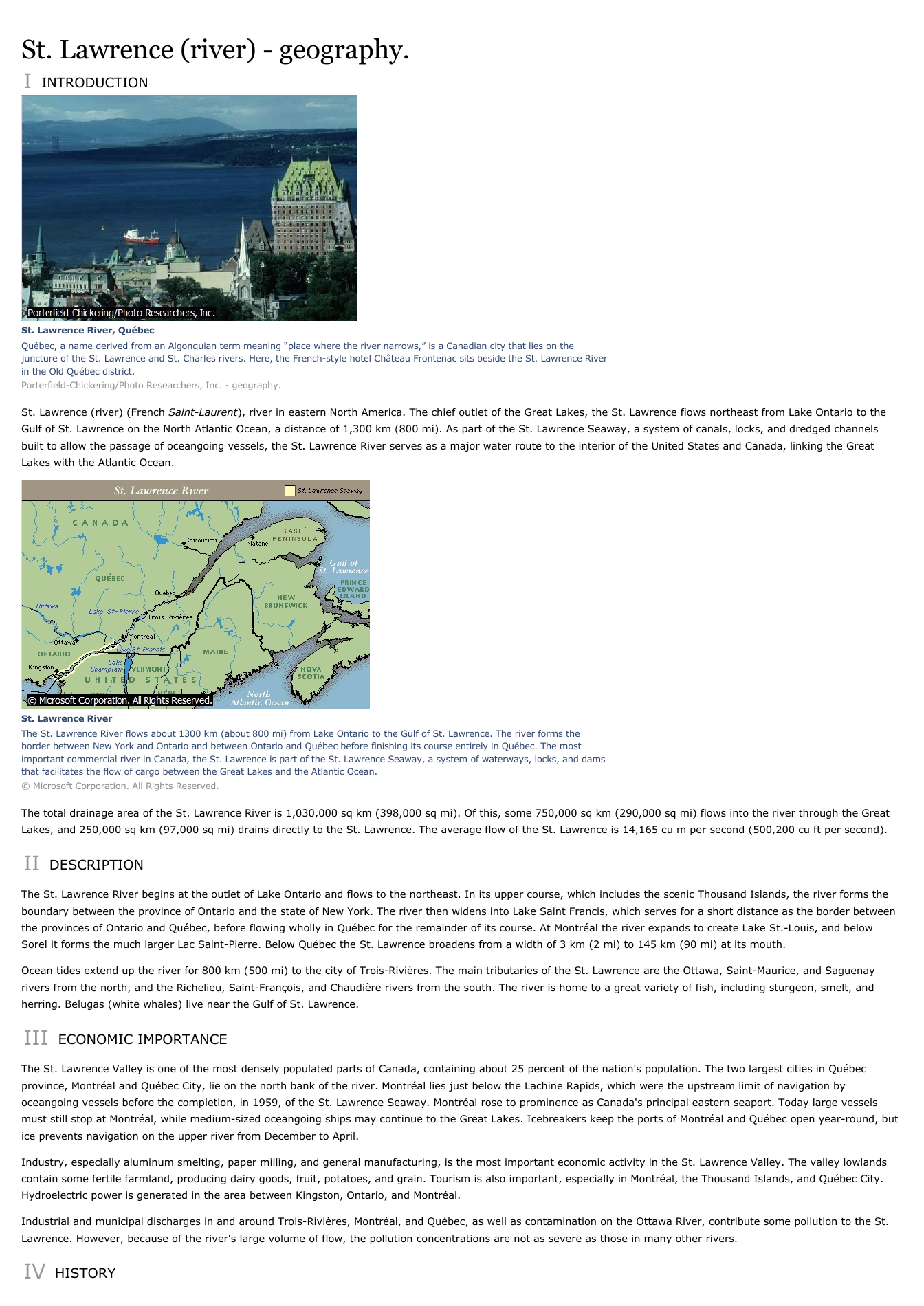
St.
Lawrence RiverThe St.
Lawrence River flows about 1300 km (about 800 mi) from Lake Ontario to the Gulf of St.
Lawrence.
The river forms theborder between New York and Ontario and between Ontario and Québec before finishing its course entirely in Québec.
The mostimportant commercial river in Canada, the St.
Lawrence is part of the St.
Lawrence Seaway, a system of waterways, locks, and damsthat facilitates the flow of cargo between the Great Lakes and the Atlantic Ocean.© Microsoft Corporation.
All Rights Reserved.
The total drainage area of the St.
Lawrence River is 1,030,000 sq km (398,000 sq mi).
Of this, some 750,000 sq km (290,000 sq mi) flows into the river through the GreatLakes, and 250,000 sq km (97,000 sq mi) drains directly to the St.
Lawrence.
The average flow of the St.
Lawrence is 14,165 cu m per second (500,200 cu ft per second).
II DESCRIPTION
The St.
Lawrence River begins at the outlet of Lake Ontario and flows to the northeast.
In its upper course, which includes the scenic Thousand Islands, the river forms theboundary between the province of Ontario and the state of New York.
The river then widens into Lake Saint Francis, which serves for a short distance as the border betweenthe provinces of Ontario and Québec, before flowing wholly in Québec for the remainder of its course.
At Montréal the river expands to create Lake St.-Louis, and belowSorel it forms the much larger Lac Saint-Pierre.
Below Québec the St.
Lawrence broadens from a width of 3 km (2 mi) to 145 km (90 mi) at its mouth.
Ocean tides extend up the river for 800 km (500 mi) to the city of Trois-Rivières.
The main tributaries of the St.
Lawrence are the Ottawa, Saint-Maurice, and Saguenayrivers from the north, and the Richelieu, Saint-François, and Chaudière rivers from the south.
The river is home to a great variety of fish, including sturgeon, smelt, andherring.
Belugas (white whales) live near the Gulf of St.
Lawrence.
III ECONOMIC IMPORTANCE
The St.
Lawrence Valley is one of the most densely populated parts of Canada, containing about 25 percent of the nation's population.
The two largest cities in Québecprovince, Montréal and Québec City, lie on the north bank of the river.
Montréal lies just below the Lachine Rapids, which were the upstream limit of navigation byoceangoing vessels before the completion, in 1959, of the St.
Lawrence Seaway.
Montréal rose to prominence as Canada's principal eastern seaport.
Today large vesselsmust still stop at Montréal, while medium-sized oceangoing ships may continue to the Great Lakes.
Icebreakers keep the ports of Montréal and Québec open year-round, butice prevents navigation on the upper river from December to April.
Industry, especially aluminum smelting, paper milling, and general manufacturing, is the most important economic activity in the St.
Lawrence Valley.
The valley lowlandscontain some fertile farmland, producing dairy goods, fruit, potatoes, and grain.
Tourism is also important, especially in Montréal, the Thousand Islands, and Québec City.Hydroelectric power is generated in the area between Kingston, Ontario, and Montréal.
Industrial and municipal discharges in and around Trois-Rivières, Montréal, and Québec, as well as contamination on the Ottawa River, contribute some pollution to the St.Lawrence.
However, because of the river's large volume of flow, the pollution concentrations are not as severe as those in many other rivers.
IV HISTORY.
»
↓↓↓ APERÇU DU DOCUMENT ↓↓↓


